Historical Work Completed at the Project

In addition to geochemical sampling and airborne geophysics, 4090 metres of diamond drilling was completed in 2006 prior to Batero Gold's ownership. Fifteen holes were drilled to an average depth of 250 metres. The two deepest drill holes tested the main targets to total depths of 492.7 and 550 metres.

The majority of the drill holes ended in gold mineralization. Indications are that the largest of the intrusions, La Cumbre, continues to the north, south, and east and is open at depth. This porphyry body, measuring 400x400x200 metres, has been successfully tested by five drill holes resulting in the presence of widespread, low grade gold mineralization.

Of the drill holes, a significant discovery was made at La Cumbre from hole DD-8. It intersected 276 metres of 0.75 g/t gold and 0.14% copper from surface to a vertical depth of 150 metres. This intersection was followed up with hole DD-18 which was drilled 250 metres to the south. Significant low-grade gold mineralization was confirmed at surface and intermittently continued to 520 metres depth.

The strike and depth extension of the mineralization intersected in hole DD-8 remains to be systematically tested.

Matecana Zone

The Matecaña porphyry zone was discovered at the project from a reconnaissance exploration program. A linear chip sampling program was conducted and results determined a similar diorite composition to La Cumbre porphyry deposit. This also is coincident with an approximate 400 metres x 500 metres strong magnetic anomaly. The Matecaña porphyry is located at an elevation of 1610 metres, 340 metres in elevation below La Cumbre porphyry.

The Matecaña porphyry discovery occurs on/or adjacent to the Amarilla Structural Corridor what is developing to be a potentially high-grade gold corridor. Five drill holes have been completed with a new discovery of porphyry mineralization at or near surface (see October 31, 2011 news release). These holes were drilled to test surface gold and geophysical anomalies, and three drill holes intersected gold and copper mineralization indicating strong potential for further porphyry style mineralization in the target area.

El Centro Zone

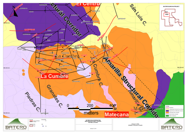
The El Centro Zone is bordered by Dos Quabradas porphyry in the North and La Cumbre porphyry in the South and it is comprised of three targets, El Cedral to the East, Manzanillo to the West and La Leguita in the middle.

El Cedral Target

Detailed mapping at the NE edge of "La Cumbre" porphyry zone discovered the El Cedral target area. Currently, the main working hypothesis is this area represents a potential epithermal high sulphidation type environment.

New exploration drilling at El Centro (El Cedral) zone, intersected gold and copper mineralization. QAP-DDH-033 is located approximately 250 metres ENE from the platform at La Lenguita where newly discovered porphyry-related mineralization near surface was intersected.  The zone will continue to be defined as this new discovery of mineralization demonstrates further evidence that porphyry-related mineralization may be linked between exploration target areas and La Cumbre -- Dos Quebradas porphyry zones.

The Company will define the size and extent of the near surface high grade gold epithermal mineralization in and adjacent to the Amarilla Structural Corridor, which is contiguous to the eastern boundary of La Cumbre porphyry. Further to defining the higher grade gold oxidation zone, in 2012 the Company will test the continuation of this mineralized horizon to the east beyond the eastern contact of La Cumbre porphyry past the Amarilla Structural Corridor to the under explored area at El Cedral. Initial prospecting in this area confirms an extensive oxidation horizon with anomalous gold-in-soil anomalies.

La Lenguita Target

La Lenguita is situated 500m northeast of La Cumbre and is an exploration drill target area. La Lenguita's geomorphology is characterized by a landform feature trending greater than 300 metres (long axis) and comprised of pervasive silicification and potassic alteration.

Six drill holes have been released at La Lenguita located approximately 850 meters south of the Dos Quebradas porphyry and approximately 500 metres east of Manzanillo's new discovery. Five of the six drill holes have intercepted gold and copper mineralization with significant intervals intercepted from near surface including a new discovery of high grade gold epithermal mineralization intersected at depth. These shallow gold and copper intercepts and new high grade discovery at depth will continue to be explored.

Porphyry-related mineralization discovered at La Lenguita may be expanded west approximately 500 metres to the new discovery at Manzanillo and north approximately 850 metres to the Dos Quebradas porphyry. This is significant as it demonstrates further evidence that porphyry-related mineralization may be linked between exploration target areas and the La Cumbre and Dos Quebradas porphyry centres.

Manzanillo Target

Manzanillo is an exploration high priority target area. This area is located east of La Lenguita-San Luis and is approximately 600m x 600m in surface area defined by Batero's ground geophysics, geochemical sampling and field mapping. Manzanillo is associated with a Miocene intrusive center. This intrusive center is composed by dikes and stocks emplaced in intermediate to felsic volcanic rocks of the Miocene Combia Formation and in Cretaceous basalts.

Four holes have been drilled at the Manzanillo target area located approximately 350 meters NNE of the La Cumbre porphyry and approximately 500 meters west of the La Lenguita target area. All drill holes intercepted gold and copper mineralization.

Of significance, QAP-DDH-034 intersected from 9.7m below surface the highest grade interval at the project thus far from a zone of newly identified epithermal mineralization returning grades averaging:

•3.73 g/t Au and 0.02% Cu over 23.3m including 11.42 g/t Au over 5.8 metres

The epithermal mineralization discovered at Manzanillo in drill hole QAP-DDH-034 potentially extends the Amarilla Structural Corridor's higher grade epithermal gold mineralization trend 600 metres to the NNW to Manzanillo from recognized epithermal gold mineralization recovered from approximately 600 metres of historic tunnels located in the central zone of the Amarilla Structural Corridor (see Figure 1 and Gold Mines Acquisition news release dated May 10, 2011). These significant, shallow gold intercepts are currently unbracketted, and will be delineated in the 2012 drill program.

Additionally, porphyry mineralization was intersected at Manzanillo in all holes lending evidence that the gold and copper mineralization may be expanded south to the La Cumbre porphyry and NNE to the La Lenguita new porphyry discovery. This is significant as it demonstrates further potential that La Cumbre porphyry may extend its boundaries significantly.

Dos Quebradas Porphyry

Detailed systematic exploration within the Dos Quebradas porphyry was initiated in 2006. This program included detailed mapping (1:2500 scale mapping), geochemical soil surveys and ultimately a 2006 diamond drilling program. The Dos Quebradas porphyry covers an area approximately 700m x 700m from mapping and baseline geology work.

The 2011 drill program has shown continuity of the Dos Quebradas system, which the drill results show extends the porphyry to the south greater than 115 metres with mineralization present at surface and at depth. (see November 3, 2011 news release)

Click to view a pdf

Quinchia Project Overview

Overview

The Batero-Quinchia Project encompasses multiple porphyry gold target centres that have been early stage drill tested in 2006. Three historic Miocene intrusive centers have been identified, spaced out over a 3km north-south strike length trend, and are at elevations between 1600m and 1950m. These intrusive centres are composed of dykes and stocks emplaced in intermediate to felsic volcanic rocks of the Miocene Combia Formation and in Cretaceous basalts. All target centres host gold and copper mineralization. Additional targets have been identified from the Company's Phase 1 field program comprising field mapping and geochemical and geophysical programs.

The Batero-Quinchia Project is located within the Municipality of Quinchia, Department of Risaralda, Republic of Colombia, approximately 55 kilometres to the north of the regional capital, Pereira. The property consists of a 1,407.43 hectare tenement and is supported with full infrastructure including roads, water and power. The Municipality of Quinchia is recognized as a stable and secure social and political environment.

All of the mineralized zones encountered to date, together with the Amarilla Structural Corridor's epithermal gold mineralization, are part of a large, regional mineralizing system/mineral district covering more than 300 hectares. This district's recognized core extends over two kilometres from La Cumbre through the "El Centro" Zone (Manzanillo, La Lenguita, and El Cedral target areas) to Dos Quebaradas. Further, Batero's new exploration drilling discovery at Matecana, located approximately 800 meters SE from La Cumbre porphyry, indicates the district has strong potential to be expanded with further drilling. The potential successful expansion of new mineralization from Matecana to La Cumbre would further extend the North to South strike length of the project's gold-copper mineralization to approximately 3 kilometres.

Progress is advancing aggressively. On the ground, however, Batero is doing more than just explore. We are also investing in environmental and social programs to help build positive relationships with local communities and ensure the sustainability of the company's long-term objectives.

The Middle Cauca Belt hosts two significant gold deposits: Marmato (9.8 million ounces of gold contained; Gran Colombia - located approximately 20 kilometre's north of the Batero-Quinchia Project) and La Colosa (12.3 million ounces of gold; AngloGold Ashanti -- located approximately 100 kilometre's SSE of the Batero-Quinchia Project). This belt is also host to other significant porphyry gold deposits including Titiribi, La Mina, and Quebradona.

Colombian Gold Belts and Districts:

Subcategories