Overview
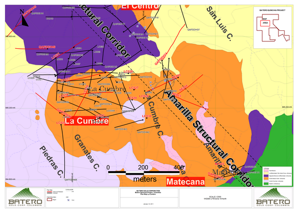
The Batero-Quinchia Project encompasses multiple porphyry gold target centres that have been early stage drill tested in 2006. Three historic Miocene intrusive centers have been identified, spaced out over a 3km north-south strike length trend, and are at elevations between 1600m and 1950m. These intrusive centres are composed of dykes and stocks emplaced in intermediate to felsic volcanic rocks of the Miocene Combia Formation and in Cretaceous basalts. All target centres host gold and copper mineralization. Additional targets have been identified from the Company's Phase 1 field program comprising field mapping and geochemical and geophysical programs.
The Batero-Quinchia Project is located within the Municipality of Quinchia, Department of Risaralda, Republic of Colombia, approximately 55 kilometres to the north of the regional capital, Pereira. The property consists of a 1,407.43 hectare tenement and is supported with full infrastructure including roads, water and power. The Municipality of Quinchia is recognized as a stable and secure social and political environment.
All of the mineralized zones encountered to date, together with the Amarilla Structural Corridor's epithermal gold mineralization, are part of a large, regional mineralizing system/mineral district covering more than 300 hectares. This district's recognized core extends over two kilometres from La Cumbre through the "El Centro" Zone (Manzanillo, La Lenguita, and El Cedral target areas) to Dos Quebaradas. Further, Batero's new exploration drilling discovery at Matecana, located approximately 800 meters SE from La Cumbre porphyry, indicates the district has strong potential to be expanded with further drilling. The potential successful expansion of new mineralization from Matecana to La Cumbre would further extend the North to South strike length of the project's gold-copper mineralization to approximately 3 kilometres.
Progress is advancing aggressively. On the ground, however, Batero is doing more than just explore. We are also investing in environmental and social programs to help build positive relationships with local communities and ensure the sustainability of the company's long-term objectives.
Project Opportunities
Trade-off studies that include additional exploration of the Antenna and Cumbre Sur oxide targets are being considered. These areas were defined through 1H 2013 exploration results and are located within 200 meters of the proposed La Cumbre open pit. The Antenna and Cumbre Sur exploration targets are outside the current mineral resource area.
Continue with a more extensive metallurgical testing program using a variety of samples. Relevant to the PEA, the test program should investigate the impact of heap leaching and vat leaching mineralization at various crush sizes as well as the effect of leach time, solution application rate, stacking height, cyanide concentration, and rest cycles on the overall metallurgical behavior of the mineralization.
Core loss through triple tube drilling in 2012 was observed as reduced in comparison to 2011 drilling. Grade improvement was observed with reduced core loss. Further review of core loss from 2011 drilling for grade differential to 2012 drilling is recommended.
Exploration Targets and Epithermal Mineralization
Targets generated by Batero in 2013 via data compilation, new mapping, and sampling include two areas with potential for gold mineralization within an oxide zone, both adjacent to the La Cumbre deposit (Antenna and Cumbre Sur), six targets for vein or fault controlled mineralization with samples results ranging from 1.0 g/t Au to 36.6 g/t Au (Kobey, Matecana, Triunfo, La Perla, Llanadas, Esmeralda), and a single target for a gold-copper porphyry style deposit (Esmeralda SW) such as La Cumbre, El Centro, and Dos Quebradas (Table 1).
Table 1 Exploration Targets
Batero Gold Corp. – Batero-Quinchia Project
Target Name
|
Mineralization Style
|
Soil Anomaly Components
|
Geophysical Anomaly type
|
Antenna
|
Oxide Au
|
Au
|
|
Cumbre Sur
|
Oxide Au
|
Au, Cu
|
|
Kobey
|
High grade vein
|
Au, Ag, As, Sb, Hg
|
Linear structure
|
Matecana
|
High grade vein
|
Au, Cu, Ag, As, Sb, Pb, Zn
|
Linear & intrusion structures
|
Triunfo
|
High grade vein
|
Au, Cu, Ag, As, Sb, Hg, Pb, Zn
|
Linear structure
|
La perla
|
High grade vein
|
Au, Cu, Zn
|
Linear structure
|
Llanadas
|
High grade vein
|
Au, Cu, Ag, Hg
|
Linear structure
|
Esmeralda
|
High grade vein
|
Cu, Ag, As, Sb, Hg, Pb, Zn
|
Linear structure
|
Esmeralda SW
|
Porphyry
|
Au, Cu, Ag, Sb, Mo
|
Intrusion structure
|
Epithermal mineralization discovered within and adjacent to the La Cumbre deposit, as well as structurally controlled mineralization throughout the El Centro and Dos Quebradas deposit areas require further investigation. Higher grade intersections including two metres grading 43.4 g/t Au in hole LC003, 31.3 m grading 2.85 g/t Au in hole QAP034, 10 m grading 1.4 g/t Au in hole SB007, and 53.6 m grading 1.31 g/t Au in hole LC001, occur in the porphyry mineralization.
In addition, there are high grade results from samples collected from several rehabilitated tunnel exposures. Results to highlight from the La Cumbre Mines tunnels include selective 2m grab samples from fault-vein structures that are summarized in Table 2. Standardized 2m tunnel back samples from the La Cumbre Mines tunnels taken across fault-vein structures are listed in Table 3. Lateral channel samples from the La Cumbre Mines tunnels taken outside of fault and vein structures within wallrock are listed in Table 4.
Table 2 La Cumbre Mines Vein Grab Sample Highlights
Batero Gold Corp. – Batero-Quinchia Project
Location
|
Length (m)
|
g/t Au
|
g/t Ag
|
Tunnel TULC6
|
Grab
|
16.65
|
5.3
|
Tunnel TULC6
|
Grab
|
7.26
|
4.5
|
Tunnel TULCPP
|
Grab
|
7.76
|
51.5
|
Tunnel TULCPP
|
Grab
|
6.92
|
34.9
|
Tunnel TULC2
|
Grab
|
5.45
|
69.8
|
Tunnel TULCPP
|
Grab
|
5.40
|
47.8
|
Tunnel TULCPP
|
Grab
|
4.12
|
25.0
|
Tunnel TULCPP
|
Grab
|
2.69
|
3.9
|
Tunnel TULCPP
|
Grab
|
2.97
|
2.9
|
Table 3 La Cumbre Mines Two Metre Vein Sample Highlights
Batero Gold Corp. – Batero-Quinchia Project
Location
|
Length (m)
|
g/t Au
|
g/t Ag
|
Tunnel TULC8
|
2
|
13.2
|
11.7
|
Tunnel TULC3
|
2
|
3.53
|
8.3
|
Tunnel TULC8
|
2
|
3.13
|
20.6
|
Table 4 La Cumbre Mines Wallrock Sample Highlights
Batero Gold Corp. – Batero-Quinchia Project
Location
|
Length (m)
|
g/t Au
|
g/t Ag
|
Tunnel TULC2
|
4
|
3.62
|
4.4
|
Tunnel TULCPP
|
8
|
1.23
|
1.3
|
Tunnel TULCPP
|
4
|
1.19
|
1.2
|
Tunnel TULCPP
|
6
|
1.10
|
2.3
|
Tunnel TULC2
|
10
|
0.69
|
2.9
|
Tunnel TULC2
|
81
|
1.19
|
15.0
|
Mandeval Mines tunnels highlights of selective grab samples from mineralized fault-vein structures are summarized in Table 5.
Table 5 Mandeval Mines Vein Grab Sample Highlights
Batero Gold Corp. – Batero-Quinchia Project
Location
|
Length (m)
|
g/t Au
|
g/t Ag
|
Tunnel 7
|
Grab
|
64.50
|
26.4
|
Tunnel 7
|
Grab
|
11.65
|
19.8
|
Principal Tunnel
|
Grab
|
9.57
|
228.0
|
Principal Tunnel
|
Grab
|
6.92
|
34.9
|
Principal Tunnel
|
Grab
|
5.68
|
35.7
|
Principal Tunnel
|
Grab
|
4.66
|
47.1
|
Principal Tunnel
|
Grab
|
8.99
|
56.5
|
Authors and Qualified Persons Statement
The PEA results contained in this news release were prepared by or under the supervision of Mr. Luke Evans, M. Sc., P.Eng., of RPA, Mr. Glen Ehasoo, P.Eng., of RPA, and Dr. Kathleen Ann Altman, Ph.D., P.E., of RPA, who are independent "Qualified Persons" under NI 43-101 Standards of Disclosure for Mineral Projects.
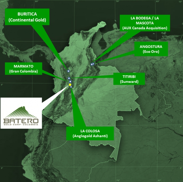
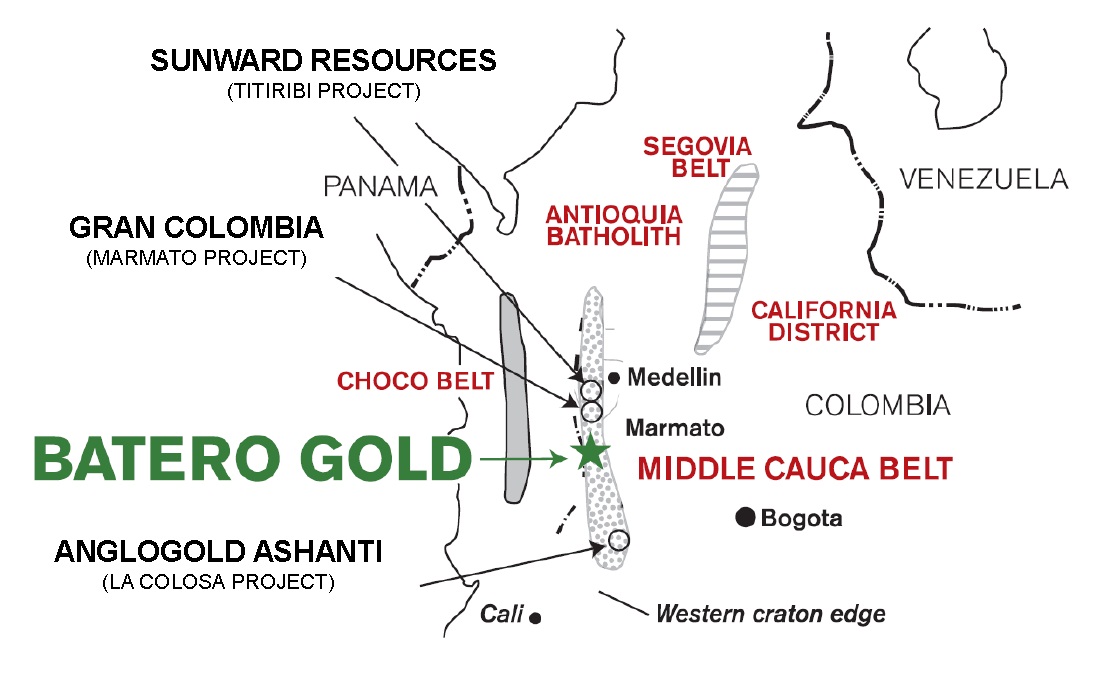
The Middle Cauca Belt hosts two significant gold deposits: Marmato (12.4 million ounces of gold contained; Gran Colombia - located approximately 20 kilometre's north of the Batero-Quinchia Project) and La Colosa (16.27 million ounces of gold; AngloGold Ashanti -- located approximately 100 kilometre's SSE of the Batero-Quinchia Project). This belt is also host to other significant porphyry gold deposits including Titiribi, La Mina, and Quebradona.